GEOG 360 Midterm Exam | Questions with Verified Answers
Document Content and Description Below
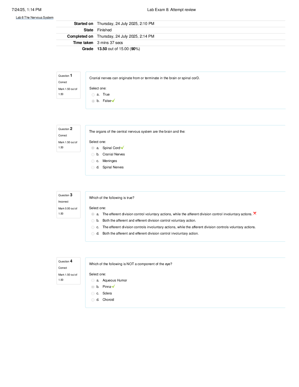
GEOG 360 Midterm Exam | Questions with Verified Answers Which of the following topological relationships describe the arc-node relationship in the coverage model? Connectivity Which of the followin ... g is true about the vector data model? -The model uses points, lines, and polygons to represent simple spatial features. -The representation of spatial features using the vector data model depends on map scale. -The model uses x-, y-coordinates to store the geometry of spatial features. Select the following statements that are true about a GIS database: -Real world data is represented as separate thematic layers -Data from different thematic layers are combined through analysis -Thematic layers organize spatial and attribute data Multipart features are used to represent multiple geographic objects that represent parts of the same entity True A geological map showing bore holes, faults, and rock outcrops that emit radon (in that order) could be captured into the GIS as: Points, lines, and areas. Topological data layers often ease data processing and maintain spatial integrity, at the cost of more complex data structures. True What type of data (nominal, ordinal, or interval/ratio) would an attribute be if it recorded height of the tallest tree in a city? Interval/ratio What type of attribute is human population (the number of people in a state) in a data layer for the U.S.? Interval/ratio What type of attribute is political party of the current governor for a states data layer for the U.S.? Nominal Which of the following is true about a line feature? - A line feature is made of line segments (arcs). - A line connects two end points (nodes). - The shape of a line is defined by arcs connected by vertices. Choose all of the statements that are true about attribute tables: -An attribute table is associated with each thematic layer in a vector data model. -A single row in the attribute table corresponds to each feature -Each feature is given a unique numeric identifier within the attribute table. A line digitized in a vector GIS is considered a ___ object. one dimensional Match the topological characteristic to the most appropriate answer: Adjacency Connected polygons Match the topological characteristic to the most appropriate answer: Connectivity Line network Match the topological characteristic to the most appropriate answer: Planar topology Non-overlapping polygons Match the topological characteristic to the most appropriate answer: Polygon topology Right and left sides You have a spatial data layer for country life expectancy rates, with boundaries and an attribute table. What type of data (nominal, ordinal, interval/ratio) are rankings for life expectancy contained in the data table? Ordinal In the vector data model, starting and ending points of a line are referred to as nodes, with vertices representing the intermediate X,Y coordinates in a linear feature. True Topology is: The spatial relationship between features on a map You have a spatial data layer for Minnesota school districts, with boundaries and an attribute table. What type of data (nominal, ordinal, interval/ratio) are rankings for graduation rate, contained in the data table? Ordinal The cell coordinate of a raster cell is usually defined as a point at the center of the cell. True If a raster has the cell dimension of 30 meters, then the area of a cell in this raster measures: 900 square meters A raster with a larger cell dimension has a higher resolution than a raster with a smaller cell dimension. False Raster data structures are able to represent discrete objects more accurately than vector data structures. False If possible, raster cell dimension should be smaller than the distance between the closest two objects in a point data set because: Multiple objects may fall in the same cell Vector data models are typically simpler than raster data models False Raster data are typically a more natural and appropriate structure to represent and analyze networks. False Match the data type on the left to the most appropriate characteristic on the right: Byte 256 values Match the data type on the left to the most appropriate characteristic on the right: Binary 0/1 Match the data type on the left to the most appropriate characteristic on the right: ASCII 127 defined codes Match the data type on the left to the most appropriate characteristic on the right: Two byte unsigned 0 to 65,535 Match the data type on the left to the most appropriate characteristic on the right: ANSI 256 defined codes Select all of the statements that are true: -cell size should be no more than twice the desired accuracy and precision for the data represented -If greater spatial detail is needed, a smaller cell size should be chosen. -The smaller the cell dimension the larger the overall size of the dataset. Which raster data structure stores the cell values by row and by group? Run length code Overlaying different layers of data in a raster facilitates simple and rapid area analyses. True Indicate the following statement that is FALSE Pointers require significant time for manual linking The value of a raster cell may be assigned in a number of ways, including: -a "winner-take-all" value -a point physical value -a discrete value -a statistical value Raster data models have a simpler structure True Which of the following statements are true about the North American Datum of 1983 (NAD 83)? -NAD83 is a newer datum than NAD27. -NAD83 is based on a satellite-determined spheroid. Geographic north is equal to grid north over most areas of the UTM projection False UTM zones are 6 degrees wide True State plane zones within a state may have different projection surfaces, e.g., both LCC and TM True Lines of constant longitude, meridians, merge at the poles. True The true shape of the Earth is most accurately described as a: Geiod The two common map projections used for the SPC (State Plane Coordinate) system are: Transverse Mercator and Lambert conformal conic Which coordinate does a false easting apply to? X When comparing spatial data in the conterminous US created using NAD 27 versus NAD 83, the difference in horizontal geographic location can be as great as: 200 meters Geographic North and Magnetic North are the same in only a few or no instances on all projected maps True There are 180 UTM zones False, there are only 60 zones Zone boundaries in the state plane system are typically defined along county boundaries True Match the corresponding angles of rotation in the Geograhic coordinate system: Zero Longitude Prime Meridian Match the corresponding angles of rotation in the Geograhic coordinate system: Zero Latitude Equator Match the corresponding angles of rotation in the Geograhic coordinate system: 90 degrees latitude North Pole Match the corresponding angles of rotation in the Geograhic coordinate system: -90 degrees latitude South Pole Match the corresponding dimensions of the oblate ellipsoid: semi-major axis radius in the equatorial direction Match the corresponding dimensions of the oblate ellipsoid: semi-minor axis radius in the polar direction Map projection is a process of converting from a three-dimensional surface to a two-dimensional surface. Which datum are GPS readings based on? WGS84 Magnetic North doesn't change through time False Some state plane zones use meters, other use feet for distance units True Most maps, whether digital or harcopy, usually contain the following map elements (check all that apply): -data pane -legend -north arrow -scale bar Digitizing is the process by which coordinates from a map or image source are converted into points, lines or polygons in digital form in a GIS. The common modes of manual digitizing are: -hard copy digitizing -on-screen digitizing Scan digitizing is generally simpler than manual digitizing because manual editing is almost completely eliminated False In map design, the data pane usually contains the legend, and little else False Match each term to the definition that best describes it: neatline bounding line on a map border Match each term to the definition that best describes it: graticule lines depicting latitude/longitudes on a map Match each term to the definition that best describes it: grid lines depicting coordinate system lines of constant value on a map Match each term to the definition that best describes it: data pane region containing geographic map elements Match each term to the definition that best describes it: legend region containing descriptive map elements In map design, map scale, size and area are driven primarily by the intended purpose of the map. True A larger scale map covers less ground than a smaller scale map of the same physical size True In the communication of spatial information, match the terms with the correct phrase: physical and resource limitations how In the communication of spatial information, match the terms with the correct phrase: intended audience for whom In the communication of spatial information, match the terms with the correct phrase: area of interest Where In the communication of spatial information, match the terms with the correct phrase: information to communicate What In field digitization with GNSS, data can be collected as individual X,Y coordinates (points) or as sequences of points as lines and areas. True Select the minimum number of satellites that are required to obtain an accurate 3D GNSS location: 4 Carrier phase measurements are usually quicker than code phase measurements True Carrier phase measurements can use one or two frequencies True PDOPs generally increase in canyons True PDOPs generally decrease in the mountains True Collecting with higher PDOPs generally results in smaller positional errors False Which of the following data sets are created based mainly on high resolution images (defined here as images with smaller than 10m pixels, or taken at a scale of 1:40,000 or larger)? -OpenStreetMap -National Wetlands Inventory -SSURGO soils data Check the advantages of map service data over local data: -A single, standard copy may be maintained across a wide range of users -They save disk space SSURGO The largest-scale digital soils data available STATSGO Coarse-scale digital soils data DLG Vector data on transportation, hydrography, boundaries, and other mapped features NLCD Raster landcover data DOQQ Terrain and tilt-corrected digital images NLCD Information on land use for the entire U.S. DRG Scanned images of USGS quadrangle and smaller scale maps HUC Codes for specifying watersheds 95 - Emergent Herbaceous Wetland NLCD NASS-CDL Corn TIGER Population per square mile NWI L1UB2 wetland type Rank the following sources from most detail (1) to coarsest or least detail (4) image sources for spatial data 1. HRO orthophotos 2.NAIP images 3.Landsat - NLCD 4.MODIS FEMA Source of digital floodplain data [Show More]
Last updated: 1 year ago
Preview 4 out of 14 pages

Loading document previews ...
Buy this document to get the full access instantly
Instant Download Access after purchase
Buy NowInstant download
We Accept:

Reviews( 0 )
$14.50
Can't find what you want? Try our AI powered Search
Document information
Connected school, study & course
About the document
Uploaded On
Oct 16, 2024
Number of pages
14
Written in
All

Additional information
This document has been written for:
Uploaded
Oct 16, 2024
Downloads
0
Views
31