Question
Answered step-by-step
Problem Statement : Use cisco packet software to solve this The...
Problem Statement: Use cisco packet software to solve this
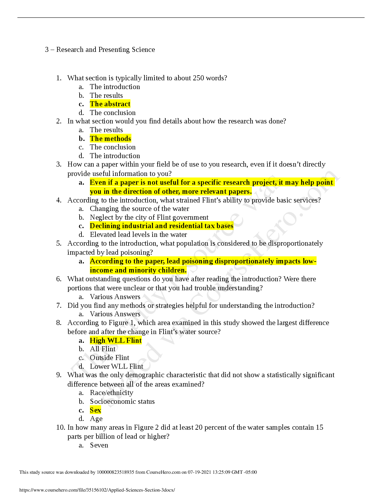
The world of communications is moving faster and faste
...
Question
Answered step-by-step
Problem Statement : Use cisco packet software to solve this The...
Problem Statement: Use cisco packet software to solve this
The world of communications is moving faster and faster. The continuous growth of network system complexity and the need of reduced design time render the development of effective and efficient networking strategies to assist the designer. The statement for the complex engineering problem is given below: a) Identification of the various problems in computer network that need to be optimum. b) Exploring the possibilities of using different and new approaches in the problems. c) Exploring the use of new techniques in network optimization.
Route Details:
The Flight Network Map (FNM) is a project for designing and implementing effective graph analysis algorithms to efficiently calculate lowest-cost paths for a variety of criteria. You will be given a list of cities (calculate coordinate locations using map if needed), and a list of international airport flights (edges). Using these lists, you will build a representation of the associated graph, and analyze it using any algorithm to design minimum cost tree connecting a set of cities and then answer specific questions such as shortest distance between cities, minimum number of hops between a pair of source and destination cities. Consider you have to travel from USA to Multan. You can travel by air from USA to Karachi international airport via connecting flight from Islamabad and then drive to Multan but make sure with connecting at least four different cities from the given list to reach destination. The nodes of the graph will represent countries/cities and edge path costs will be calculated by using driving distances between pairs of cities connected by a direct road (for simplicity, ignore red lights, stop signs, toll roads and other obstructions) and speed (Last two digits of your registration number), calculated time will be taken as cost.
Cities
(Hyderabad, Makli, Sanghar, Larkana, Sadiqabad, Kot Addu, Jacobabad, Derabugti)
Tasks
(a) Compute the best path using the criterion of minimizing the total time taken (Cost) to reach the destination. (10)
(b) Using the algorithm find a) the source vertex, b) the shortest path tree, and c) the resulting devalues. (30)
(c) Implement OSPF algorithm code for the city wise configuration on packet tracer and show the results. (20)
Project Deliverables:
As a minimum, the following requirements are to be submitted by the project deadline:
1. Everyone needs to demonstrate the simulated results based on the given specifications. (10)
2. Report including detailed description of weighted graphs and area wise configuration with IP addressing including tables maintained for the topology: (30)
here is some solution
First we need to define all the possible paths which are as follows.
We have to see all possible paths from Google map so that there is minimum of four cities in between Karachi to Multan
1.PNG
To find the edge weights we have used following formula:
S is our distance
V is our speed
t is time take to reach the destination point
For our case the above equation is rewritten as:
My Roll ID= 160234
So
Where V is equal to 34 Km/h.
Distance:
We can find the distance between two cities using Google MAP
2.PNG
3.jpg
Now we can apply Dijkstra Algorithm to find the shortest path between Karachi and Multan, as shown below.
4.PNG
5.jpg
[Show More]


 Charles Herrick - 100 Q&A About Alcoholism & Drug Addiction-Jones and Bartlett Publishers, Inc.png)