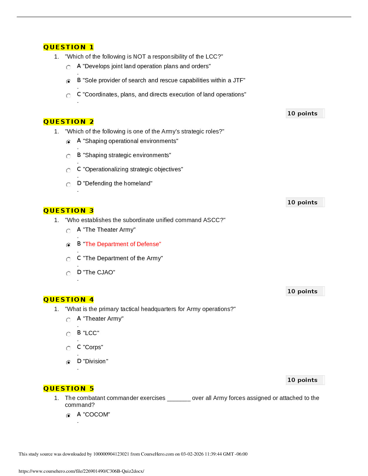
Land Navigation/Map Reading(Army
Board Study Guide)
What is the Field Manual for map reading and land navigation? - ✔✔FM 3-25.26
What are the basic colors of a map, and what does each color represent? - ✔✔Black -
Ind
...
Land Navigation/Map Reading(Army
Board Study Guide)
What is the Field Manual for map reading and land navigation? - ✔✔FM 3-25.26
What are the basic colors of a map, and what does each color represent? - ✔✔Black -
Indicates cultural (man-made) features such as buildings and roads, surveyed spot
elevations, and all labels.
Red-Brown - The colors red and brown are combined to identify cultural features, all
relief features, non-surveyed spot elevations, and elevation, such as contour lines on
red-light readable maps.
Blue - Identifies hydrography or water features such as lakes, swamps, rivers, and
drainage.
Green - Identifies vegetation with military significance, such as woods, orchards, and
vineyards.
Brown - Identifies all relief features and elevation, such as contours on older edition
maps, and cultivated land on red-light readable maps.
Red - Classifies cultural features, such as populated areas, main roads, and
boundaries, on older maps.
Other - Occasionally other colors may be used to show special information. These are
indicated in the marginal information as a rule.
What are military symbols? - ✔✔Figures used to represent types of military
organizations, installations, and activities
Where is the Legend of the map found? - ✔✔Lower left margin
What are contour lines? - ✔✔Imaginary lines on the ground connecting equal elevation,
they represent high and low ground elevation
What are 3 types of contour lines? - ✔✔1. Index
2. Intermediate
3. Supplementary
How many Mils are in one Degree? - ✔✔17.7 mils
How many North's are there on a military map? - ✔✔1. True north
2. Magnetic north
3. Grid north
What shape are the contour lines that indicate a hill? - ✔✔A hill is shown on a map by
contour lines forming concentric circles. The inside of the smallest closed circle is the
hilltop.
What shape are the contour lines that indicate a saddle? - ✔✔A saddle is normally
represented as an hourglass
What shape are the contour lines that indicate a valley? - ✔✔Contour lines forming a
valley are either U-shaped or V-shaped.
What shape are the contour lines that indicate a Ridge? - ✔✔Contour lines forming a
ridge tend to be U-shaped or V-shaped. The closed end of the contour line points away
from high ground.
What shape are the contour lines that indicate a depression? - ✔✔Usually only
depressions that are equal to or greater than the contour interval will be shown. On
maps, depressions are represented by closed contour lines that have tick marks
pointing toward low ground.
What shape are the contour lines that indicate a draw? - ✔✔The contour lines depicting
a draw are U-shaped or V-shaped, pointing toward high ground.
What shape are the contour lines that indicate a spur? - ✔✔Contour lines on a map
depict a spur with the U or V pointing away from high ground
What shape are the contour lines that indicate a cliff? - ✔✔Cliffs are also shown by
contour lines very close together and, in some instances, touching each other.
What shape are the contour lines that indicate a cut? - ✔✔This contour line extends the
length of the cut and has tick marks that extend from the cut line to the roadbed, if the
map scale permits this level of detail.
What shape are the contour lines that indicate a fill? - ✔✔This contour line extends the
length of the filled area and has tick marks that point toward lower ground. If the map
scale permits, the length of the fill tick marks are drawn to scale and extend from the
base line of the fill symbol.
What must be done to a map before it can be used? - ✔✔It must be oriented.
What are 5 major terrain features found on a map? - ✔✔1. Hill
2. Ridge
3. Valley
4. Saddle
5. Depression
What are the 3 minor terrain features found on a military map? - ✔✔1. Draw
2. Spur
3. Cliff
What are the 2 supplementary terrain features found on a military map? - ✔✔1. Cut
2. Fill
What is a map? - ✔✔A map is a graphic representation of a portion of the earth's
surface drawn to scale, as seen from above.
What is an azimuth? - ✔✔A horizontal angle, measured in a clockwise manner from a
north base line, expressing direction.
What is vertical distance? - ✔✔The distance between the highest and lowest points
measured.
What is a contour interval? - ✔✔The vertical distance between adjacent contour lines on
a map.
What is the distance between grid lines on a combat map? - ✔✔1 kilometer or 1000
meters
How many mils are there in a circle? - ✔✔6400 mils in 360 degrees
Which north is used when using a military map? - ✔✔Magnetic north when using a
compass, and grid north when using the map
How would you hold a lensatic compass? - ✔✔Away from metal (weapons, electrical
devices), level and firm
Name two ways to hold a compass? - ✔✔1. Compass-to-Cheek Method
2. Center-Hold Method
Are topographic symbols drawn to scale? - ✔✔No
What do topographic symbols represent? - ✔✔Man-made and natural features
In military symbols, what colors are used for a map overlay and what do they represent?
- ✔✔Blue- Friendly forces
Red-Enemy forces
Black- boundaries
Yellow-contaminated area both friendly and enemy
Green- engineer obstacles, both friendly and enemy
What is Back Azimuth? - ✔✔The opposite direction of an azimuth.
How do you figure out a back azimuth? - ✔✔To obtain a back azimuth from an azimuth,
add 180 degrees if the azimuth is 180 degrees or less; subtract 180 degrees if the
azimuth is 180 degrees or more
What is a declination diagram? - ✔✔Shows the angular relationship between the
magnetic north, grid north and true north
What is the general rule for reading military grid coordinates? - ✔✔Right and Up
How many sights does a compass have? - ✔✔2
What is a benchmark? - ✔✔A man-made marker showing points of elevation
What are parallels of latitude? - ✔✔Measured distances going north or south of the
equator
What is an aerial photograph? - ✔✔An aerial photograph is any photograph taken from
an airborne vehicle (aircraft, drones, balloons, satellites, and so forth)
What does UTM stand for? - ✔✔Universal Transverse Mercator
The lensatic compass has a bezel ring; each bezel ring click is equal to how many
degrees? - ✔✔3
How many times would the bezel
[Show More]


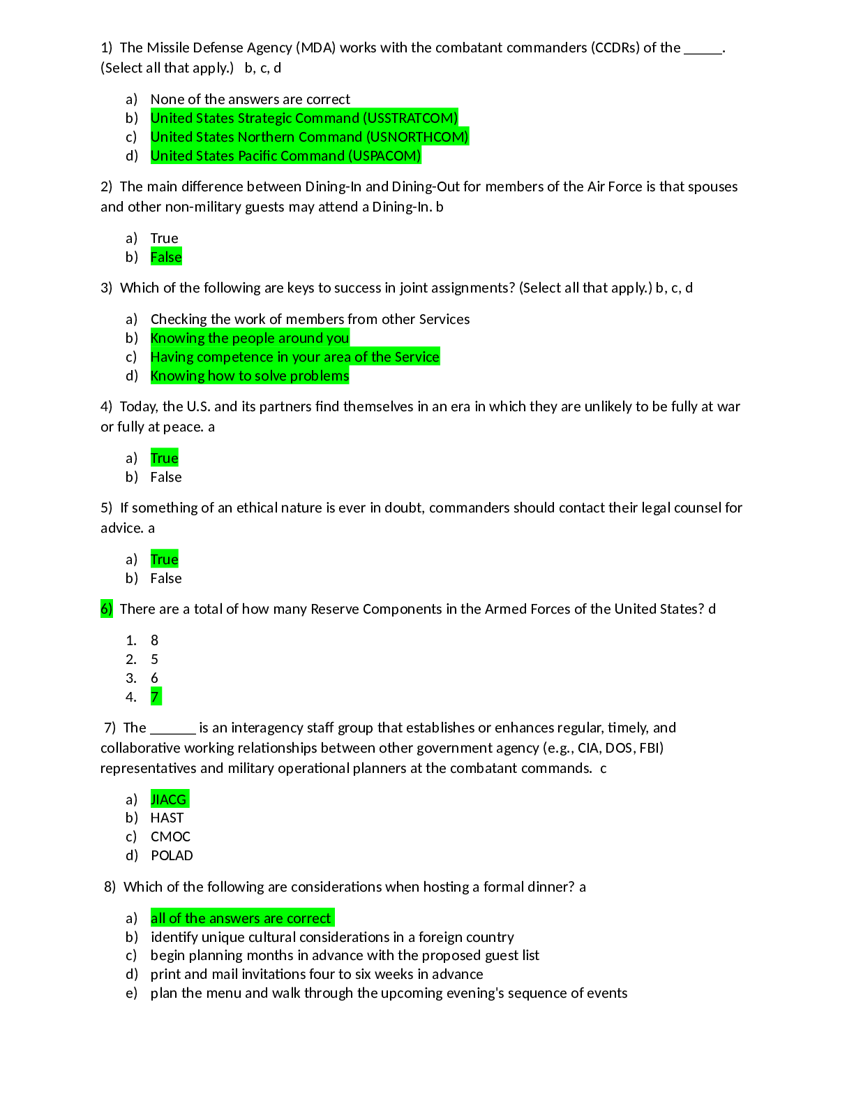
.png)
.png)
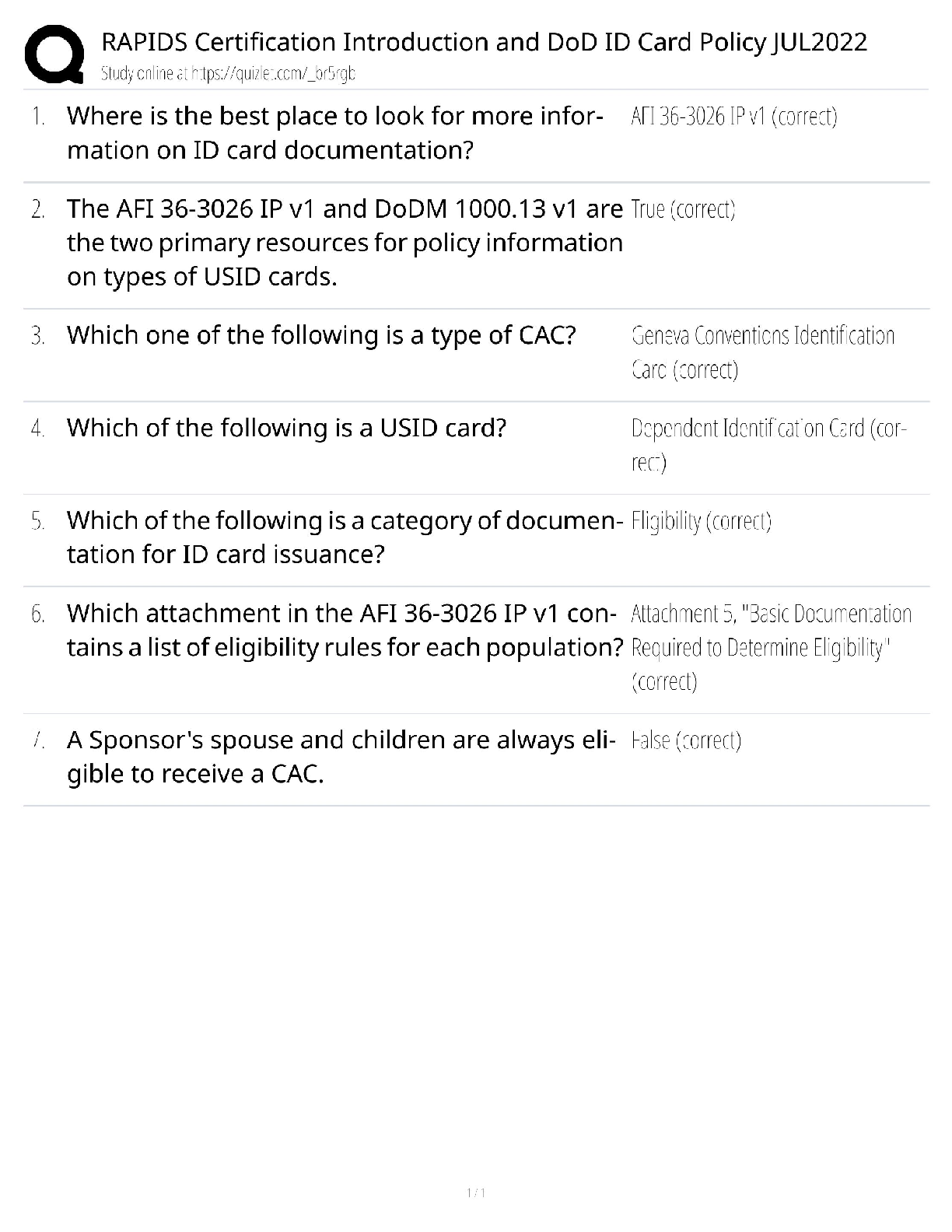


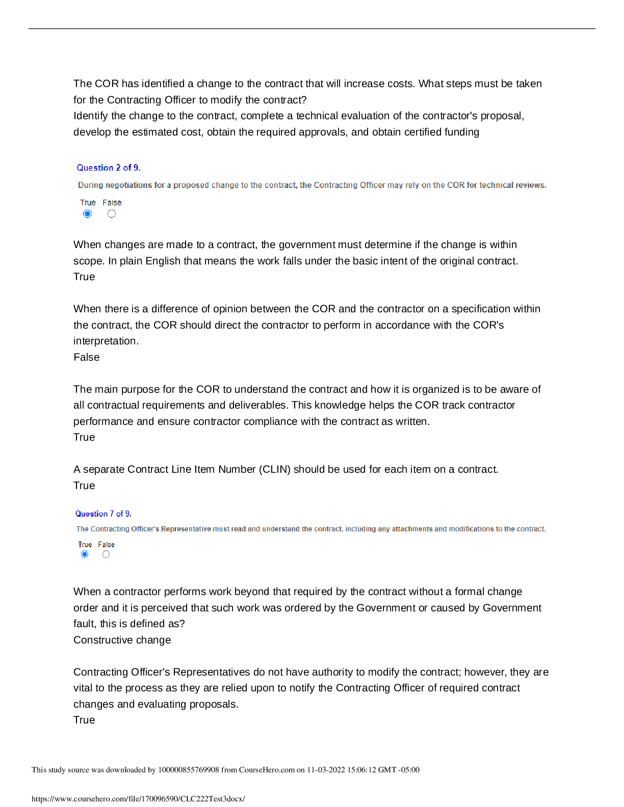


![Preview of [SOLVED] EDCO 740 / EDCO740 Quiz 1 (LATES 2021/2022 Graded A)](https://scholarfriends.com/storage/EDCO_740_Quiz_1.png)
